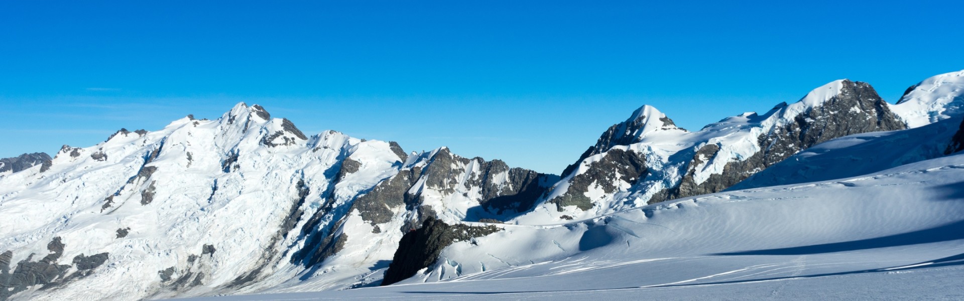
The fourteen highest peaks on the planet are emblems of nature's awe-inspiring grandeur, cultural significance, and cinematic attractiveness. These legendary mountains continue to fascinate the human spirit via exploration, film, and adventure, transcending boundaries and encouraging a global community to embrace the challenges, triumphs, and secrets of high-altitude exploration. Join us on this thrilling trip as we dig into the worlds of climbing, culture, and film, solving the enigma of these great peaks one summit at a time.
14 Tallest Mountain Peaks in the World exceeding 8000 meters
Table of Contents
The fourteen highest peaks on the earth, each of which bears witness to the breathtaking majesty of nature, have captivated people's attention for millennia. These mountains, from the tallest in the world, Everest to Savage Mount K2, and other technical Mountain Peaks symbolize not just physical achievements in the field of climbing but also human struggle, resiliency, and the never-ending pursuit of exploration. In this article, many facets of these famous peaks, including their geological significance, cultural veneration, and cinematic depictions have been covered.
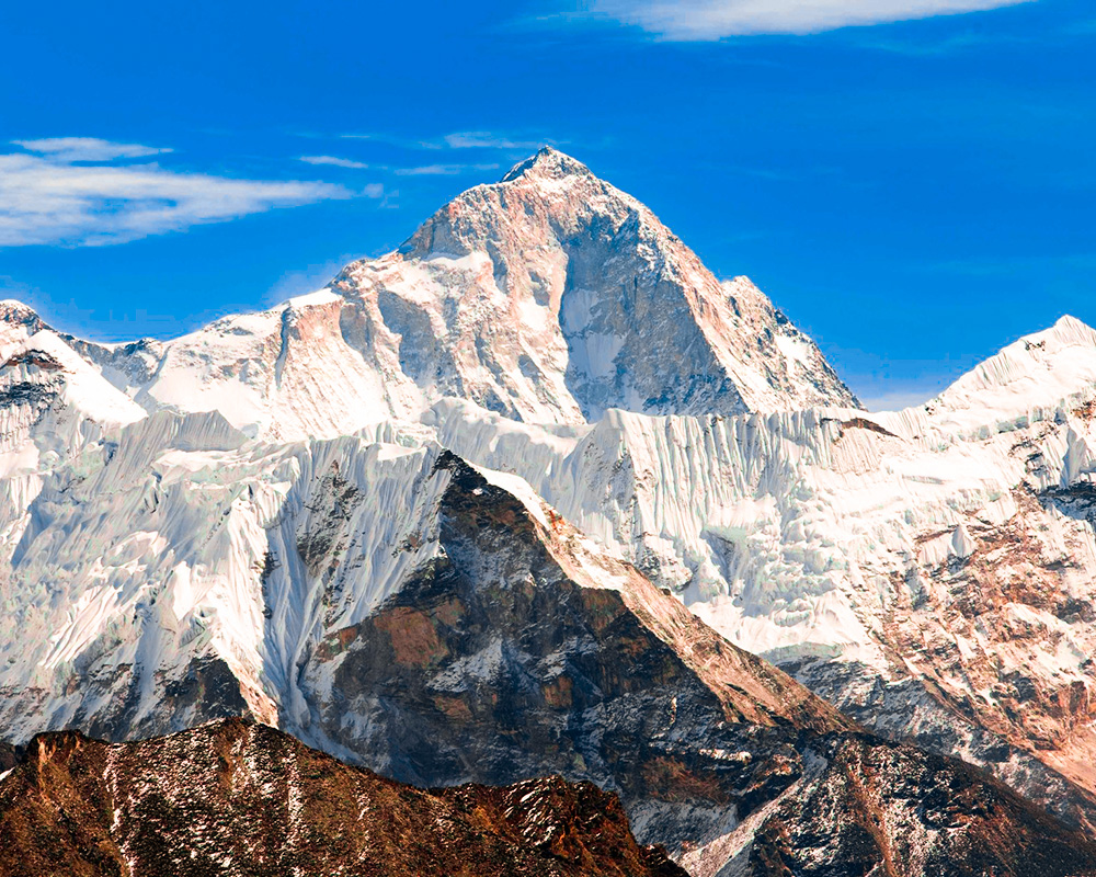
Everest (Sagarmatha)
- Altitude: 8,848.86 meters (29,032 feet)
- Country: Nepal & Tibet
- Base Camp: 5346 meters (17,539 feet)
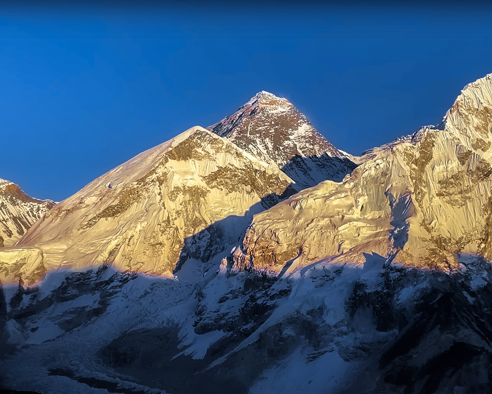
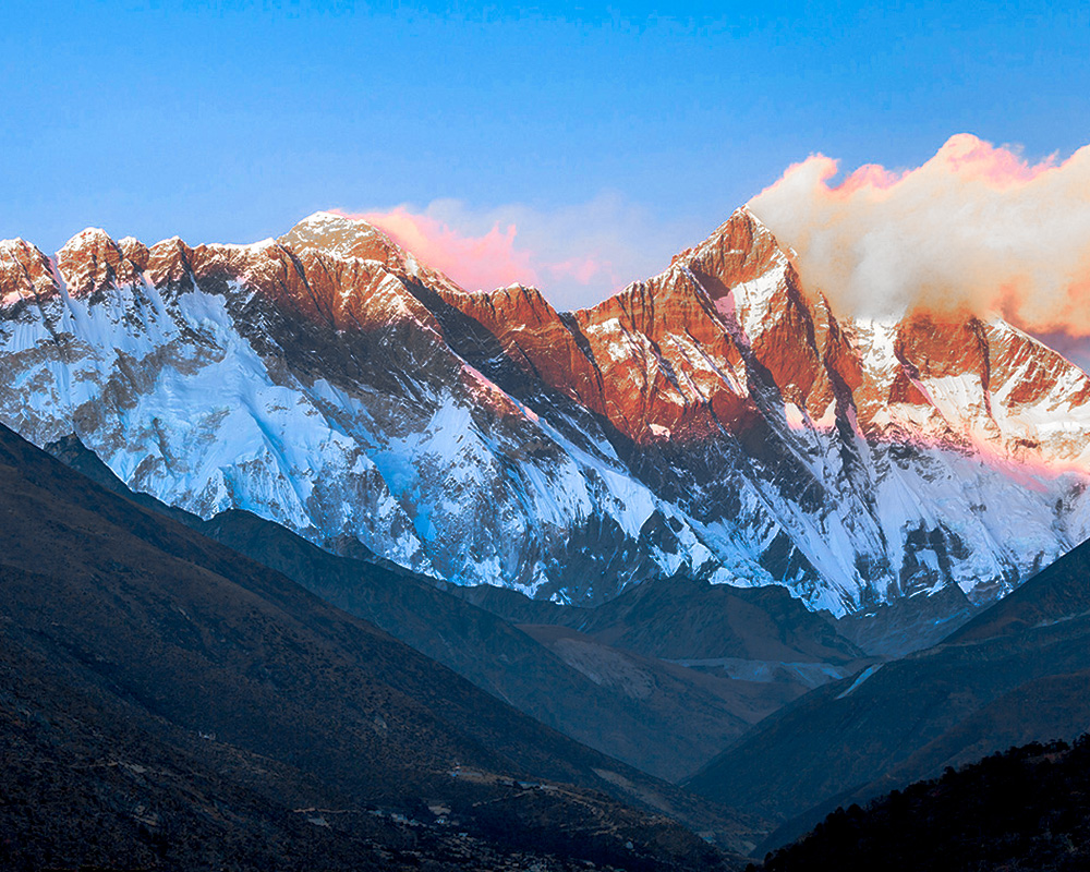
Situated in the Himalayas, Everest straddles the border between Nepal and the Tibet Autonomous Region of China. Everest, at 8,848.86 meters above sea level, is the highest peak in the world and is significant in both cultural and mountaineering contexts. Its Nepali name, Sagarmatha, means "Goddess of the Sky," indicating its sacred status, also Tibetan has its name Chomolungma.
On May 29, 1953, Sir Edmund Hillary and Tenzing Norgay Sherpa accomplished the first confirmed ascent via the Southeast Ridge making Sherpa Ethnics a strong foundation of mountaineering. Strong obstacles await climbers on Everest, such as the perilous Khumbu Icefall, high altitude circumstances in the "death zone," and severe weather patterns. Growing tourism has put the mountain's ecosystem in danger, prompting measures like trash management and conservation efforts.
Also, every year thousands and thousands of trekkers take an Everest Base Camp Trek, to honor the majesty of the world, the tallest nature on the planet, Mount Everest.
K2
- Altitude: 8,611 meters (28,251 feet)
- Country: Pakistan & China
- Base Camp: 5150 meters (16,896 feet)
Located in the Karakoram Range, straddling the Pakistan-China border. As the second-highest peak at 8,611 meters, K2 is renowned for its pyramid-shaped peak and challenging climbing routes, earning the moniker "Savage Mountain." The mountain has a storied history marked by numerous expeditions, with significant challenges attributed to its steep ascent and unpredictable weather conditions.
K2 holds cultural significance for local communities, including the Balti people of Pakistan, who revere the mountain in folklore and traditions. K2 has one of the highest fatality rates among the eight thousanders, attributed to its technical difficulty, avalanches, and challenging terrain. This savage beauty has always been the dream of incredible mountaineers and a lifetime accomplishment for the conquerors.
Kanchenjunga
- Altitude: 8,586 meters (28,169 feet)
- Country: Nepal & India
- Base Camp: 5160 meters (16,929 feet)
Situated between Nepal and the Indian state of Sikkim, Kanchenjunga stands at 8,586 meters. Kanchenjunga is renowned for its rich biodiversity, encompassing diverse ecosystems from subtropical forests to alpine meadows, contributing to its designation as a UNESCO World Heritage site.
The mountain's first ascent was in 1955 by a British expedition from Sikkim's Side but didn’t reach the exact summit. Kanchenjunga holds sacred significance for local communities, including the Limbu and Rai people and the people of Sikkim, and the Indian Government made expeditions not permitted from the east.
Efforts are underway to promote sustainable tourism and conservation initiatives in the Kanchenjunga region, Kanchenjunga Round Trek is nowadays gaining popularity, addressing environmental concerns and supporting local communities.
Lhotse
- Altitude: 8,516 meters (27,940 feet)
- Country: Nepal & Tibet
- Base Camp: Everest Base Camp, 5346 meters (17,539 feet)
Adjacent to Mount Everest in the Everest region, Lhotse stands at 8,516 meters. Lhotse is connected to Everest by the South Col and shares similar geological formations, including the treacherous Khumbu Icefall and Lhotse Face. Lhotse offers challenging climbing routes, including the South Col route, attracting experienced mountaineers seeking to summit both Everest and Lhotse.
There are instances when Lhotse is wrongly recognized as the Everest massif's southern summit. Lhotse climbing was not given much thought until after Everest had been successfully climbed. Two Swiss, Fritz Luchsinger and Ernest Reiss, made the first ascent of Lhotse in 1956 starting from Everest Base Camp.
Lhotse holds cultural significance within the Sherpa community and Tibetan Buddhist traditions, reflecting its proximity to Everest and shared cultural heritage. Lhotse has witnessed numerous expeditions, contributing to mountaineering achievements and explorations in the Everest region. There are two subsidiary peaks in addition to the main summit: Nuptse, a high peak on the mountain's west ridge, and Lhotse Shar, which is located directly east of the main summit.
Makalu
- Altitude: 8,485 meters (27,838 feet)
- Country: Nepal & Tibet
- Base Camp: 5000 meters (16,404 feet)
Located southeast of Mount Everest in the Mahalangur Himalayas, Makalu stands at 8,485 meters. Makalu is characterized by its steep pyramid-shaped peak and challenging climbing conditions, including technical rock and ice sections, considered to be one of the most difficult mountains to climb.
The Makalu-Barun Valley, adjacent to the mountain, is renowned for its rich biodiversity, encompassing diverse ecosystems from tropical forests to alpine meadows.
The first ascent of Makalu in 1955 by a French expedition marked a significant milestone in Himalayan exploration, followed by subsequent ascents via various routes. 568 people have made a successful summit to Makalu by 2019, and 48 have fallen apart with tragedy on mountaineering.
Cho Oyu
- Altitude: 8,188 meters (26,864 feet)
- Country: Nepal & Tibet
- Base Camp: 4900 meters (16,076 feet) to advance Base Camp 5,800 meters (19,028 feet)
Cho Oyu is the sixth-highest mountain in the world, rising to a height of 8,188 meters, and is located on the boundary between Nepal and China. Cho Oyu is regarded as one of the easier eight-thousanders to reach, drawing climbers looking for a less strenuous approach than other peaks. A variety of climbing routes, such as the Northwest Face and Southwest Ridge, are available on Cho Oyu to suit different climbing skill levels and expedition preferences.
Since its initial ascent in 1954, Cho Oyu has been part of many expeditions that have advanced mountaineering accomplishments and explorations in the Himalayas. Cho Oyu's common cultural past and border location with China make it culturally significant to Tibetan Buddhist traditions and residents.
Dhaulagiri
- Altitude: 8,167 meters (26,795 feet)
- Country: Nepal
- Base Camp: 4740 meters (15,551feet)
Located in the western region of Nepal, Dhaulagiri stands at 8,167 meters, characterized by its massive size and challenging climbing routes. Dhaulagiri is known for its impressive north and south faces, offering challenging climbing conditions, including technical rock and ice sections.
Dhaulagiri’s peak stretches over thirty miles, offering shape to an otherwise convoluted topography of twisting ridges, glaciers, and ice falls. Along the main crest, many pyramid-shaped summits rise. Numbered from east to west, four of these summits are higher than 25,000 feet.
The first ascent of Dhaulagiri in 1960 by a Swiss-Austrian expedition marked a significant milestone in Himalayan exploration, followed by subsequent ascents via various routes. Dhaulagiri holds cultural significance for local communities in the western region of Nepal, including the Gurung and Magar people, who celebrate the mountain in religious and cultural traditions.
Manaslu
- Altitude: 8,163 meters (26,781 feet)
- Country: Nepal
- Base Camp: 4800 meters (15,748 feet)
Situated in the Mansiri Himal, part of the Nepalese Himalayas, Manaslu stands at 8,163 meters. Manaslu Conservation Area surrounding the mountain is renowned for its rich biodiversity, encompassing diverse ecosystems from subtropical forests to alpine meadows.
The tenth-highest peak in the world, Annapurna, is roughly 40 kilometers to the east of it. The mountain's long ridges and valley glaciers provide accessible routes from all directions, and when viewed from a distance, the top rises sharply above the surrounding terrain and is a prominent sight.
The first ascent of Manaslu in 1956 by Toshio Imanishi and Gyalzen Norbu, from a Japanese expedition marked a significant milestone in the Manaslu Expedition. The peak is thought to be less difficult to climb than Everest because of its lengthy ridges and valley glaciers. Because of its propensity for avalanches, over 60 people have perished there. Manaslu holds cultural significance within the Gurung and Tibetan Buddhist communities, reflecting its location in the Gorkha District and shared cultural heritage. Manaslu is referred to as the "Mountain of Spirit" by the locals referring to intellect or Soul (Manasa), You can also explore the diversity around this Spiritual mountain with Manaslu Circuit Trek.
Nanga Parbat
- Altitude: 8,126 meters (26,660 feet)
- Country: Pakistan
- Base Camp: 3,850 meters (12,631 feet)
Located in the western Himalayas in the Pakistani-administered area of Kashmir, Nanga Parbat stands at 8,126 meters, earning the nickname "King of the Mountain" with treacherous climbing conditions also renowned as "Killer Mountain". Nanga Parbat is known for its steep slopes and challenging climbing routes, including the treacherous Rupal Face and Diamir Face.
The first ascent of Nanga Parbat in 1953 by an Austrian-German expedition marked a significant milestone in Himalayan exploration, followed by subsequent ascents via various routes. Nanga Parbat holds cultural significance for local communities in Pakistan, including the Diamer and Astore Valley communities, who celebrate the mountain in religious and cultural traditions.
Annapurna
- Altitude: 8,091 meters (26,545 feet)
- Country: Nepal
- Base Camp: 4130 meters (13,549 feet)
Located in central Nepal, Annapurna stands at 8,091 meters, known for its treacherous climbing conditions and high fatality rate among the fourteen eight-thousanders. A ridge formed by the Annapurna massif is roughly thirty miles long, connecting the Kali (Kali Gandak) and Marsyandi gorges. Annapurna is characterized by its steep slopes and challenging climbing routes, including the South Face, which remains one of the most challenging ascents in mountaineering.
The first ascent of Annapurna in 1950 by a French expedition marked a significant milestone in Himalayan exploration, followed by subsequent ascents via various routes. Since 32% of attempts to reach the summit of the peak end in death, it is commonly referred to as the deadliest mountain in the world. The Hindu goddess of food and nutrition, believed to reside there, inspired the name Annapurna. Annapurna holds cultural significance within the Gurung and Tibetan Buddhist communities in Nepal.
Numerous hiking paths provide breathtaking vistas of the Annapurna Range. Some excellent routes to see the massifs are the Annapurna Base Camp Trek and the Annapurna Circuit Trek. These are Nepal's eight highest peaks.
Gasherbrum I (Hidden Peak, K5)
- Altitude: 8,080 meters (26,509 feet)
- Country: Pakistan & China
- Base Camp: 4800 meters (15,748 feet)
The Gasherbrum group is situated in the Karakoram Range on the Pakistan-China border, comprising multiple peaks including Gasherbrum I (Hidden Peak and K5) as the eleventh-highest peak and Gasherbrum II as the thirteenth-highest. The Gasherbrum Peaks are known for their impressive stature and challenging climbing conditions, including technical rock and ice sections.
The first ascent of Gasherbrum I in 1958 by an American expedition marked a significant milestone in Himalayan exploration, followed by subsequent ascents of both Gasherbrum I and II. The Gasherbrum Peaks hold cultural significance for local communities in Pakistan, including the Balti people of the Gilgit-Baltistan region, who revere the mountains in folklore and traditions. Gasherbrum I is the second-highest mountain in the Karakorum range and is rarely scaled.
Broad Peak
- Altitude: 8,051 meters (26,414 feet)
- Country: China & Pakistan
- Base Camp: 4850 meters (15,908 feet)
Situated in the Karakoram and Baltoro Muztagh Range on the China-Pakistan border, Broad Peak stands at 8,051 meters, known for pyramid Shape, its impressive stature, and challenging climbing routes. The first ascent of Broad Peak in 1957 by an Austrian expedition marked a significant milestone in Himalayan exploration led by Marcus Schmuck.
The summit's length of almost 1.5 kilometers (7.8 miles) gives it the impression of a "broad peak," which is accurately described by the name of the mountain. There are five summits on this mountain: Rocky Summit (8028 m), Broad Peak Central (8011 m), Broad Peak North (7490 m), Kharut Kangri (6942 m), and Broad Peak (8051 m).
Broad Peak is significant within the Balti and other local communities in Pakistan, reflecting its location in the Karakoram Range within 5 miles from K2.
Gasherbrum II (K4)
- Altitude: 8,035 meters (26,362 feet)
- Country: China, Pakistan & Gilgit–Baltistan
- Base Camp: 5150 meters (16,896 feet)
Gasherbrum II, sometimes referred to as K4, is an 8,035-meter-tall member of the Gasherbrum group located in the Karakoram Range on the boundary between China and Pakistan. It means "Shining Wall," according to some, because of how brilliant the peak is. In actuality, though, the name derives from two Balti words, "rgasha" and "brum," which together indicate "beautiful mountain."
The British Royal Engineer Thomas George Montgomerie successfully summited this mountain K4 and the Karakorum in 1856. Among the 8,000-meter peaks in the Karakoram, Gasherbrum II is regarded as the most "easy" and safest to reach.
Shishapangma (Gosainthan)
- Altitude: 8,027 meters (26,335 feet)
- Country: China & Pakistan
- Base Camp: 5,600 meters (18,372 feet)
At 8,027 meters, Shishapangma, also called Gosainthan, is the 14th highest peak in the world and is situated in the Tibet Autonomous Region of China. Compared to other peaks, Shishapangma is thought to be one of the easier eight-thousanders to reach, drawing climbers looking for a less strenuous climb.
Shishapangma provides several climbing routes, including the Northwest Face and Southwest Ridge, that suit a variety of climbing skills and adventure styles. Since Hsu Ching and his Chinese team made the mountain's first climb in 1964. Due to the restriction of climbing in Shishapangma, very few or major expeditions with specific purposes are permitted and have low summit counts.